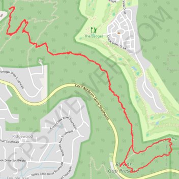
Fanning Trail in Blevins Gap Preserve
- Distance: 5.3 mi
- Elevation gain: 290 m
- Maximum elevation: 409 m
- Elevation loss: 288 m
- Minimum elevation: 232 m
- Moving time: 2 h 10 m
- Moving speed: 2.4 mph
- Maximum speed: 4.2 mph
- Total time: 2 h 16 m
- Global speed: 2.3 mph
Interactive trail map
Trail profile
- Distance: 5.3 mi
- Elevation gain: 290 m
- Maximum elevation: 409 m
- Elevation loss: 288 m
- Minimum elevation: 232 m
- Moving time: 2 h 10 m
- Moving speed: 2.4 mph
- Maximum speed: 4.2 mph
- Total time: 2 h 16 m
- Global speed: 2.3 mph
About this trail
Name: Fanning Trail in Blevins Gap Preserve trail, distance, elevation, map, profile, GPS track
Coordinates: 34.65763 -86.53049 34.67408 -86.51045
Other hiking, mountain biking, running and outdoor activity trails
Click on a trail to view its statistics, map and profile.
Fanning, Stevenson, Walsingham, Bailey Cove, and Jones Valley Loop trails
United States > Alabama > Madison County > Huntsville
Distance: 2.0 mi • Elevation gain: 143 m • Maximum elevation: 372 m
Loop hike via Jones Valley Loop, Bailey Cove, Walsingham, Fanning and unnamed trails in Blevins Preserve
United States > Alabama > Madison County > Huntsville
Distance: 3.8 mi • Elevation gain: 226 m • Maximum elevation: 418 m
Blevins Gap Nature Preserve loop
United States > Alabama > Madison County > Huntsville > Ridgewood
Distance: 8.3 mi • Elevation gain: 433 m • Maximum elevation: 458 m
Jones Valley Loop, Bailey Cove, Fanning, Scout, and in-progress Bailey Cove extension trails
United States > Alabama > Madison County > Huntsville > Huntsville Hills
Distance: 7.4 mi • Elevation gain: 379 m • Maximum elevation: 420 m
Green Mountain Loop Ride
United States > Alabama > Madison County > Huntsville > Willow Hills Estates
Distance: 31.4 mi • Elevation gain: 534 m • Maximum elevation: 445 m