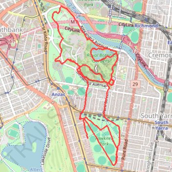
Fawkner Park and Royal Botanic Gardens loop walk
- Distance: 7.5 mi
- Elevation gain: 137 m
- Maximum elevation: 38 m
- Elevation loss: 133 m
- Minimum elevation: 6 m
- Moving time: 2 h 48 s
- Moving speed: 3.7 mph
- Maximum speed: 14.2 mph
- Total time: 3 h 10 m
- Global speed: 2.4 mph
Interactive trail map
Trail profile
- Distance: 7.5 mi
- Elevation gain: 137 m
- Maximum elevation: 38 m
- Elevation loss: 133 m
- Minimum elevation: 6 m
- Moving time: 2 h 48 s
- Moving speed: 3.7 mph
- Maximum speed: 14.2 mph
- Total time: 3 h 10 m
- Global speed: 2.4 mph
About this trail
Name: Fawkner Park and Royal Botanic Gardens loop walk trail, distance, elevation, map, profile, GPS track
Start: Armadale Street, Melbourne, City of Melbourne, Victoria, 3004, Australia (-37.84112 144.97900)
Coordinates: -37.84502 144.97249 -37.82205 144.98483
Other hiking, mountain biking, running and outdoor activity trails
Click on a trail to view its statistics, map and profile.
Running around Albert Park Lake
Australia > Victoria > Melbourne
Distance: 8.1 mi • Elevation gain: 73 m • Maximum elevation: 20 m
Jolimont Station to Ashburton along Yarra River, Gardiners Creek and Ferndale Trails
Australia > Victoria > Melbourne
Distance: 9.0 mi • Elevation gain: 115 m • Maximum elevation: 56 m
Zeopoxa Cycling
Australia > Victoria > Melbourne
Distance: 7.0 mi • Elevation gain: 95 m • Maximum elevation: 31 m