Tom's Point
Chautauqua Lake Fish and Wildlife Management Area
- Distance: 0.8 mi
- Elevation gain: 3 m
- Maximum elevation: 405 m
- Elevation loss: 7 m
- Minimum elevation: 399 m
- Moving time: 15 m 30 s
- Moving speed: 2.9 mph
- Maximum speed: 3.6 mph
- Total time: 18 m 11 s
- Global speed: 2.5 mph
Interactive trail map
Trail profile
- Distance: 0.8 mi
- Elevation gain: 3 m
- Maximum elevation: 405 m
- Elevation loss: 7 m
- Minimum elevation: 399 m
- Moving time: 15 m 30 s
- Moving speed: 2.9 mph
- Maximum speed: 3.6 mph
- Total time: 18 m 11 s
- Global speed: 2.5 mph
About this trail
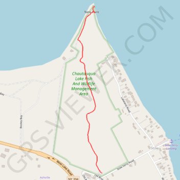
Name: Tom's Point trail, distance, elevation, map, profile, GPS track
Coordinates: 42.15529 -79.40727 42.16469 -79.40545