Silu Park, Galiano Island
- Distance: 1.5 mi
- Elevation gain: 102 m
- Maximum elevation: 73 m
- Elevation loss: 110 m
- Minimum elevation: 2 m
- Moving time: 42 m 15 s
- Moving speed: 2.1 mph
- Maximum speed: 28.5 mph
- Total time: 51 m 50 s
- Global speed: 1.7 mph
Interactive trail map
Trail profile
- Distance: 1.5 mi
- Elevation gain: 102 m
- Maximum elevation: 73 m
- Elevation loss: 110 m
- Minimum elevation: 2 m
- Moving time: 42 m 15 s
- Moving speed: 2.1 mph
- Maximum speed: 28.5 mph
- Total time: 51 m 50 s
- Global speed: 1.7 mph
About this trail
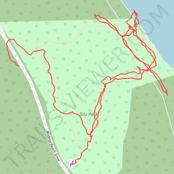
Name: Silu Park, Galiano Island trail, distance, elevation, map, profile, GPS track
Coordinates: 48.98270 -123.55002 48.98620 -123.54444
Other hiking, mountain biking, running and outdoor activity trails
Click on a trail to view its statistics, map and profile.
BBF loop to the Skydeck in Nanaimo
Canada > British Columbia > Cowichan Valley Regional District > Area A (Mill Bay / Malahat) > Mill Bay
BBF loop to the Skydeck
Distance: 201.0 mi • Elevation gain: 6,222 m • Maximum elevation: 706 m