Schunnemunk Meadows Trail
- Distance: 2.4 mi
- Elevation gain: 62 m
- Maximum elevation: 108 m
- Elevation loss: 62 m
- Minimum elevation: 74 m
- Moving time: 38 m 14 s
- Moving speed: 3.7 mph
- Maximum speed: 6.0 mph
- Total time: 42 m 7 s
- Global speed: 3.4 mph
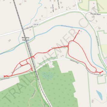
Interactive trail map
Trail profile
- Distance: 2.4 mi
- Elevation gain: 62 m
- Maximum elevation: 108 m
- Elevation loss: 62 m
- Minimum elevation: 74 m
- Moving time: 38 m 14 s
- Moving speed: 3.7 mph
- Maximum speed: 6.0 mph
- Total time: 42 m 7 s
- Global speed: 3.4 mph
About this trail
Name: Schunnemunk Meadows Trail trail, distance, elevation, map, profile, GPS track
Coordinates: 41.42572 -74.10165 41.43053 -74.08815
Other hiking, mountain biking, running and outdoor activity trails
Click on a trail to view its statistics, map and profile.
Crossing Schunnemunk State Park via Trestle Trail, Barton Swamp Trail, Schunnemunk Mountain, Megaliths, Jessup Trail and Long Path
United States > New York > Orange County > Town of Cornwall
Description:
Distance: 8.5 mi • Elevation gain: 485 m • Maximum elevation: 506 m