Make a donation
Gear up for your next adventure:
As an Amazon Associate, this site earns from qualifying purchases at no extra cost to you.
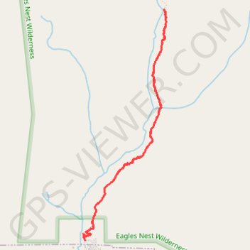
Booth Falls via Booth Lake Trail in Eagles Nest Wilderness
The Booth Falls Trail in Vail, Colorado, offers hikers a rewarding journey through diverse landscapes, including aspen groves, alpine forests, and rocky terrains. The trail culminates at the picturesque Booth Falls, a 60-foot waterfall cascading over sandstone cliffs. Along the way, hikers can enjoy panoramic views of the Vail Valley and the Gore Range, making it a memorable experience for nature enthusiasts. #Hiking #Mountain #Forest #Nature #Waterfall
- Distance: 4.0 mi
- Elevation gain: 424 m
- Maximum elevation: 2,986 m
- Elevation loss: 425 m
- Minimum elevation: 2,572 m
- Moving time: 2 h 4 m
- Moving speed: 1.9 mph
- Maximum speed: 4.1 mph
- Total time: 2 h 42 m
- Global speed: 1.5 mph
Interactive trail map
Make a donation
Gear up for your next adventure:
As an Amazon Associate, this site earns from qualifying purchases at no extra cost to you.
Trail profile
- Distance: 4.0 mi
- Elevation gain: 424 m
- Maximum elevation: 2,986 m
- Elevation loss: 425 m
- Minimum elevation: 2,572 m
- Moving time: 2 h 4 m
- Moving speed: 1.9 mph
- Maximum speed: 4.1 mph
- Total time: 2 h 42 m
- Global speed: 1.5 mph
Make a donation
Gear up for your next adventure:
As an Amazon Associate, this site earns from qualifying purchases at no extra cost to you.
About this trail
Name: Booth Falls via Booth Lake Trail in Eagles Nest Wilderness trail, distance, elevation, map, profile, GPS track
Start: Booth Lake Trail, Eagle County, Colorado, 80307, United States (39.65087 -106.32110)
End: Booth Lake Trail, Eagle County, Colorado, 80307, United States (39.65082 -106.32112)
Coordinates: 39.65082 -106.32132 39.67281 -106.31103
Make a donation
Gear up for your next adventure:
As an Amazon Associate, this site earns from qualifying purchases at no extra cost to you.
Other hiking, mountain biking, running and outdoor activity trails
Click on a trail to view its statistics, map and profile.