Never Summer 60k
- Distance: 39.2 mi
- Elevation gain: 2,566 m
- Maximum elevation: 3,608 m
- Elevation loss: 2,566 m
- Minimum elevation: 2,740 m
- Moving time: 6 h 51 m
- Moving speed: 5.7 mph
- Maximum speed: 10.0 mph
- Total time: 6 h 54 m
- Global speed: 5.7 mph
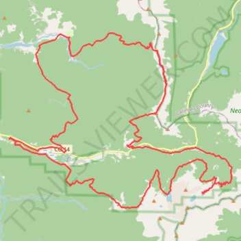
Interactive trail map
Trail profile
- Distance: 39.2 mi
- Elevation gain: 2,566 m
- Maximum elevation: 3,608 m
- Elevation loss: 2,566 m
- Minimum elevation: 2,740 m
- Moving time: 6 h 51 m
- Moving speed: 5.7 mph
- Maximum speed: 10.0 mph
- Total time: 6 h 54 m
- Global speed: 5.7 mph
About this trail
Name: Never Summer 60k trail, distance, elevation, map, profile, GPS track
Start: Gould Loop Trail, Jackson County, Colorado, United States (40.50916 -106.00331)
End: Gould Loop Trail, Jackson County, Colorado, United States (40.50918 -106.00323)
Coordinates: 40.47644 -106.00331 40.55995 -105.86353
Other hiking, mountain biking, running and outdoor activity trails
Click on a trail to view its statistics, map and profile.
Seven Utes Mountain Loop Trail
United States > Colorado > Jackson County
Distance: 10.2 mi • Elevation gain: 761 m • Maximum elevation: 3,476 m