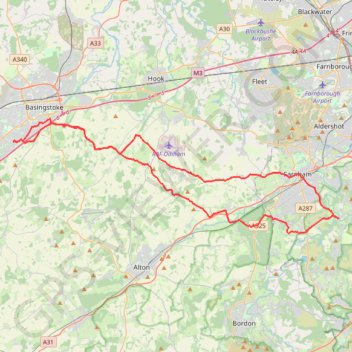
Brighton Hill - South Downs National Park
MTB loop from Brighton Hill to South Downs National Park via Upton Grey, Long Sutton, Farnham, Tilford, Holt Pound, Lodge Inclosure, Bentley, Lower Froyle and South Warnborough. #MTB #Loop #Nature #Countryside #Forest
- Distance: 42.4 mi
- Elevation gain: 914 m
- Maximum elevation: 183 m
- Elevation loss: 913 m
- Minimum elevation: 51 m
- Moving time: 3 h 47 m
- Moving speed: 11.2 mph
- Maximum speed: 33.1 mph
- Total time: 4 h 48 m
- Global speed: 8.8 mph
Interactive trail map
Trail profile
- Distance: 42.4 mi
- Elevation gain: 914 m
- Maximum elevation: 183 m
- Elevation loss: 913 m
- Minimum elevation: 51 m
- Moving time: 3 h 47 m
- Moving speed: 11.2 mph
- Maximum speed: 33.1 mph
- Total time: 4 h 48 m
- Global speed: 8.8 mph
About this trail
Name: Brighton Hill - South Downs National Park trail, distance, elevation, map, profile, GPS track
Coordinates: 51.17294 -1.12113 51.25420 -0.75143
Topography: Basingstoke and Deane topographic map, elevation, terrain
Other hiking, mountain biking, running and outdoor activity trails
Click on a trail to view its statistics, map and profile.
Millbridge, Pierrepont Farm, Farnham Brewery, Farnham
United Kingdom > England > Surrey > Waverley > Frensham > Millbridge
Distance: 7.8 mi • Elevation gain: 168 m • Maximum elevation: 111 m
Tilford to Farnham via Bourne Wood
United Kingdom > England > Surrey > Waverley > Tilford
Distance: 6.2 mi • Elevation gain: 136 m • Maximum elevation: 109 m
Caesar's Bypass Cycle Route
United Kingdom > England > Hampshire > Rushmoor
Distance: 11.5 mi • Elevation gain: 157 m • Maximum elevation: 141 m
Farnham to Tilford
United Kingdom > England > Surrey > Waverley > Farnham
Distance: 9.7 mi • Elevation gain: 186 m • Maximum elevation: 111 m