Garden Canyon Loop
Loop hike in the Garden Canyon via the Tinker Pond in the Coronado National Forest. #Hiking #Loop #Nature #Mountain #Forest #Lake
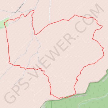
- Distance: 6.1 mi
- Elevation gain: 392 m
- Maximum elevation: 1,728 m
- Elevation loss: 393 m
- Minimum elevation: 1,547 m
- Moving time: 2 h 38 m
- Moving speed: 2.3 mph
- Maximum speed: 7.8 mph
- Total time: 3 h 6 m
- Global speed: 2.0 mph
Interactive trail map
Trail profile
- Distance: 6.1 mi
- Elevation gain: 392 m
- Maximum elevation: 1,728 m
- Elevation loss: 393 m
- Minimum elevation: 1,547 m
- Moving time: 2 h 38 m
- Moving speed: 2.3 mph
- Maximum speed: 7.8 mph
- Total time: 3 h 6 m
- Global speed: 2.0 mph
About this trail
Name: Garden Canyon Loop trail, distance, elevation, map, profile, GPS track
End: Garden Canyon Road, Sierra Vista, Cochise County, Arizona, United States (31.48019 -110.33701)
Coordinates: 31.46381 -110.33711 31.48303 -110.31169