Lake Anne Loop
Loop hike to the Lake Ann from Austin Pass via Lake Ann Trail in the Mount Baker Wilderness. #Hiking #Loop #Lake #Mountain #Nature #Forest #Wilderness
- Distance: 8.5 mi
- Elevation gain: 759 m
- Maximum elevation: 1,485 m
- Elevation loss: 754 m
- Minimum elevation: 1,199 m
- Moving time: 5 h 37 m
- Moving speed: 1.5 mph
- Maximum speed: 4.4 mph
- Total time: 6 h 33 m
- Global speed: 1.3 mph
Interactive trail map
Trail profile
- Distance: 8.5 mi
- Elevation gain: 759 m
- Maximum elevation: 1,485 m
- Elevation loss: 754 m
- Minimum elevation: 1,199 m
- Moving time: 5 h 37 m
- Moving speed: 1.5 mph
- Maximum speed: 4.4 mph
- Total time: 6 h 33 m
- Global speed: 1.3 mph
About this trail
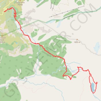
Name: Lake Anne Loop trail, distance, elevation, map, profile, GPS track
Start: Lake Ann Trail, Whatcom County, Washington, United States (48.84991 -121.68560)
End: Lake Ann Trail, Whatcom County, Washington, United States (48.84997 -121.68611)
Coordinates: 48.82495 -121.68611 48.85124 -121.64255
Other hiking, mountain biking, running and outdoor activity trails
Click on a trail to view its statistics, map and profile.
Chain Lakes and Wild Goose Trails Loop
United States > Washington > Whatcom County
From the Heather Meadows area, this loop first drops toward Bagley Dam and the open basin of Bagley Lakes, where Bagley Creek, subalpine meadows, heather, and the slopes of Table Mountain and Mount Herman shape the approach to the Chain Lakes Trail. The setting is one of the signature hiking areas of the upper…
Distance: 7.7 mi • Elevation gain: 623 m • Maximum elevation: 1,666 m
Wild Goose Trail in Mount Baker-Snoqualmie National Forest
United States > Washington > Whatcom County
The Wild Goose Trail offers hikers a diverse experience, with two sections catering to different difficulty levels. From its starting point at the Bagley Lakes parking area, the trail weaves through Heather Meadows, providing stunning views of Mount Baker, Mount Shuksan, and the surrounding peaks. Along the…
Distance: 1.7 mi • Elevation gain: 279 m • Maximum elevation: 1,576 m
Chain Lakes Trail in Mount Baker-Snoqualmie National Forest
United States > Washington > Whatcom County
The Chain Lakes Trail in Mount Baker-Snoqualmie National Forest offers a remarkable alpine experience with stunning views of towering peaks, crystal-clear lakes, and wildflower-filled meadows. Hikers will be treated to panoramic vistas of Mount Baker and Mount Shuksan while passing by serene lakes such as…
Distance: 5.2 mi • Elevation gain: 394 m • Maximum elevation: 1,666 m
Northern part of the Pacific Crest Trail (PCT)
United States > Oregon > Klamath County
Hike on the Pacific Crest National Scenic Trail from Crater Lake to Canada Border through Oregon and Washington along the Sierra Nevada and Cascade mountain ranges. #Hiking #Mountain #SierraNevada #Cascade #Nature #Forest #Park #PCT
Distance: 744.6 mi • Elevation gain: 44,308 m • Maximum elevation: 2,307 m