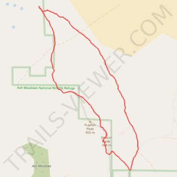
Ash Meadows National Wildlife Refuge: Longstreet Peak - Deacon Peak Loop Hike
- Distance: 6.7 mi
- Elevation gain: 383 m
- Maximum elevation: 956 m
- Elevation loss: 382 m
- Minimum elevation: 728 m
- Moving time: 2 h 53 m
- Moving speed: 2.3 mph
- Maximum speed: 5.2 mph
- Total time: 3 h 13 m
- Global speed: 2.1 mph
Interactive trail map
Trail profile
- Distance: 6.7 mi
- Elevation gain: 383 m
- Maximum elevation: 956 m
- Elevation loss: 382 m
- Minimum elevation: 728 m
- Moving time: 2 h 53 m
- Moving speed: 2.3 mph
- Maximum speed: 5.2 mph
- Total time: 3 h 13 m
- Global speed: 2.1 mph
About this trail
Name: Ash Meadows National Wildlife Refuge: Longstreet Peak - Deacon Peak Loop Hike trail, distance, elevation, map, profile, GPS track
Start: Devils Hole Road, Nye County, Nevada, United States (36.42794 -116.28812)
End: Devils Hole Road, Nye County, Nevada, United States (36.42808 -116.28835)
Coordinates: 36.42794 -116.31280 36.46348 -116.28592