Thank you for supporting this site ❤️
Make a donation
Make a donation
Gear up for your next adventure:
As an Amazon Associate, this site earns from qualifying purchases at no extra cost to you.
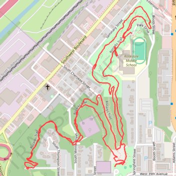
Rozarks Trail in Mount Marty Park
- Distance: 3.3 mi
- Elevation gain: 140 m
- Maximum elevation: 285 m
- Elevation loss: 130 m
- Minimum elevation: 251 m
- Moving time: 1 h 17 m
- Moving speed: 2.6 mph
- Maximum speed: 4.8 mph
- Total time: 1 h 19 m
- Global speed: 2.5 mph
Interactive trail map
Thank you for supporting this site ❤️
Make a donation
Make a donation
Gear up for your next adventure:
As an Amazon Associate, this site earns from qualifying purchases at no extra cost to you.
Trail profile
- Distance: 3.3 mi
- Elevation gain: 140 m
- Maximum elevation: 285 m
- Elevation loss: 130 m
- Minimum elevation: 251 m
- Moving time: 1 h 17 m
- Moving speed: 2.6 mph
- Maximum speed: 4.8 mph
- Total time: 1 h 19 m
- Global speed: 2.5 mph
Thank you for supporting this site ❤️
Make a donation
Make a donation
Gear up for your next adventure:
As an Amazon Associate, this site earns from qualifying purchases at no extra cost to you.
About this trail
Name: Rozarks Trail in Mount Marty Park trail, distance, elevation, map, profile, GPS track
Coordinates: 39.05753 -94.62181 39.06501 -94.61433
Thank you for supporting this site ❤️
Make a donation
Make a donation
Gear up for your next adventure:
As an Amazon Associate, this site earns from qualifying purchases at no extra cost to you.