Thank you for supporting this site ❤️
Make a donation
Make a donation
Gear up for your next adventure:
As an Amazon Associate, this site earns from qualifying purchases at no extra cost to you.
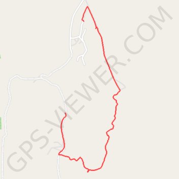
Likweti Bushveld Farm Estate
- Distance: 2.1 mi
- Elevation gain: 48 m
- Maximum elevation: 944 m
- Elevation loss: 130 m
- Minimum elevation: 814 m
- Moving time: 55 m 46 s
- Moving speed: 2.3 mph
- Maximum speed: 13.5 mph
- Total time: 1 h 7 m
- Global speed: 1.9 mph
Interactive trail map
Thank you for supporting this site ❤️
Make a donation
Make a donation
Gear up for your next adventure:
As an Amazon Associate, this site earns from qualifying purchases at no extra cost to you.
Trail profile
- Distance: 2.1 mi
- Elevation gain: 48 m
- Maximum elevation: 944 m
- Elevation loss: 130 m
- Minimum elevation: 814 m
- Moving time: 55 m 46 s
- Moving speed: 2.3 mph
- Maximum speed: 13.5 mph
- Total time: 1 h 7 m
- Global speed: 1.9 mph
Thank you for supporting this site ❤️
Make a donation
Make a donation
Gear up for your next adventure:
As an Amazon Associate, this site earns from qualifying purchases at no extra cost to you.
About this trail
Name: Likweti Bushveld Farm Estate trail, distance, elevation, map, profile, GPS track
Coordinates: -25.41828 31.04327 -25.40176 31.05004
Thank you for supporting this site ❤️
Make a donation
Make a donation
Gear up for your next adventure:
As an Amazon Associate, this site earns from qualifying purchases at no extra cost to you.