Make a donation
Gear up for your next adventure:
As an Amazon Associate, this site earns from qualifying purchases at no extra cost to you.
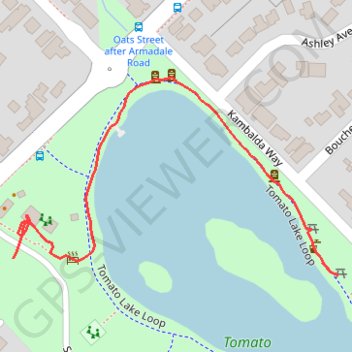
Tomato Lake
- Distance: 0.4 mi
- Elevation gain: 3 m
- Maximum elevation: 19 m
- Elevation loss: 3 m
- Minimum elevation: 16 m
- Moving time: 9 m 13 s
- Moving speed: 2.9 mph
- Maximum speed: 4.2 mph
- Total time: 13 m 51 s
- Global speed: 1.9 mph
Interactive trail map
Make a donation
Gear up for your next adventure:
As an Amazon Associate, this site earns from qualifying purchases at no extra cost to you.
Trail profile
- Distance: 0.4 mi
- Elevation gain: 3 m
- Maximum elevation: 19 m
- Elevation loss: 3 m
- Minimum elevation: 16 m
- Moving time: 9 m 13 s
- Moving speed: 2.9 mph
- Maximum speed: 4.2 mph
- Total time: 13 m 51 s
- Global speed: 1.9 mph
Make a donation
Gear up for your next adventure:
As an Amazon Associate, this site earns from qualifying purchases at no extra cost to you.
About this trail
Name: Tomato Lake trail, distance, elevation, map, profile, GPS track
Start: Tomato Lake Loop, Kewdale, City of Belmont, Western Australia, 6105, Australia (-31.97623 115.93435)
End: Scenic Drive, Kewdale, City of Belmont, Western Australia, 6105, Australia (-31.97608 115.93075)
Coordinates: -31.97623 115.93075 -31.97437 115.93435
Make a donation
Gear up for your next adventure:
As an Amazon Associate, this site earns from qualifying purchases at no extra cost to you.
Other hiking, mountain biking, running and outdoor activity trails
Click on a trail to view its statistics, map and profile.
Tomato Lake Reserve
Australia > Western Australia > City of Belmont
Distance: 0.7 mi • Elevation gain: 3 m • Maximum elevation: 19 m