Thank you for supporting this site ❤️
Make a donation
Make a donation
Gear up for your next adventure:
As an Amazon Associate, this site earns from qualifying purchases at no extra cost to you.
ציורי הסלע, הטומולוסים והר ערקוב
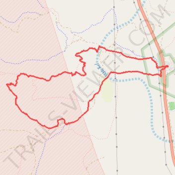
- Distance: 5.8 mi
- Elevation gain: 232 m
- Maximum elevation: 652 m
- Elevation loss: 232 m
- Minimum elevation: 519 m
- Moving time: 1 h 40 m
- Moving speed: 3.5 mph
- Maximum speed: 20.4 mph
- Total time: 1 h 51 m
- Global speed: 3.1 mph
Interactive trail map
Thank you for supporting this site ❤️
Make a donation
Make a donation
Gear up for your next adventure:
As an Amazon Associate, this site earns from qualifying purchases at no extra cost to you.
Trail profile
- Distance: 5.8 mi
- Elevation gain: 232 m
- Maximum elevation: 652 m
- Elevation loss: 232 m
- Minimum elevation: 519 m
- Moving time: 1 h 40 m
- Moving speed: 3.5 mph
- Maximum speed: 20.4 mph
- Total time: 1 h 51 m
- Global speed: 3.1 mph
Thank you for supporting this site ❤️
Make a donation
Make a donation
Gear up for your next adventure:
As an Amazon Associate, this site earns from qualifying purchases at no extra cost to you.
About this trail
Name: ציורי הסלע, הטומולוסים והר ערקוב trail, distance, elevation, map, profile, GPS track
Start: 40, Ramat Negev Regional Council, Beersheba Subdistrict, South District, Israel (30.79234 34.76861)
End: 40, Ramat Negev Regional Council, Beersheba Subdistrict, South District, Israel (30.79225 34.76868)
Coordinates: 30.78230 34.73829 30.79551 34.76868
Thank you for supporting this site ❤️
Make a donation
Make a donation
Gear up for your next adventure:
As an Amazon Associate, this site earns from qualifying purchases at no extra cost to you.