Thank you for supporting this site ❤️
Make a donation
Make a donation
Gear up for your next adventure:
As an Amazon Associate, this site earns from qualifying purchases at no extra cost to you.
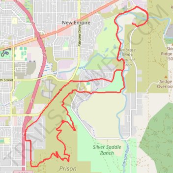
Odyssey and Desert Peach Loop via Riverview Park
- Distance: 15.6 mi
- Elevation gain: 359 m
- Maximum elevation: 1,664 m
- Elevation loss: 359 m
- Minimum elevation: 1,399 m
- Moving time: 1 h 32 m
- Moving speed: 10.0 mph
- Maximum speed: 27.4 mph
- Total time: 1 h 40 m
- Global speed: 9.3 mph
Interactive trail map
Thank you for supporting this site ❤️
Make a donation
Make a donation
Gear up for your next adventure:
As an Amazon Associate, this site earns from qualifying purchases at no extra cost to you.
Trail profile
- Distance: 15.6 mi
- Elevation gain: 359 m
- Maximum elevation: 1,664 m
- Elevation loss: 359 m
- Minimum elevation: 1,399 m
- Moving time: 1 h 32 m
- Moving speed: 10.0 mph
- Maximum speed: 27.4 mph
- Total time: 1 h 40 m
- Global speed: 9.3 mph
Thank you for supporting this site ❤️
Make a donation
Make a donation
Gear up for your next adventure:
As an Amazon Associate, this site earns from qualifying purchases at no extra cost to you.
About this trail
Name: Odyssey and Desert Peach Loop via Riverview Park trail, distance, elevation, map, profile, GPS track
Start: North Deer Run Road, Carson City, Nevada, United States (39.17917 -119.70196)
End: North Deer Run Road, Carson City, Nevada, United States (39.17944 -119.70192)
Coordinates: 39.13368 -119.74609 39.18468 -119.69570
Thank you for supporting this site ❤️
Make a donation
Make a donation
Gear up for your next adventure:
As an Amazon Associate, this site earns from qualifying purchases at no extra cost to you.