Thank you for supporting this site ❤️
Make a donation
Make a donation
Gear up for your next adventure:
As an Amazon Associate, this site earns from qualifying purchases at no extra cost to you.
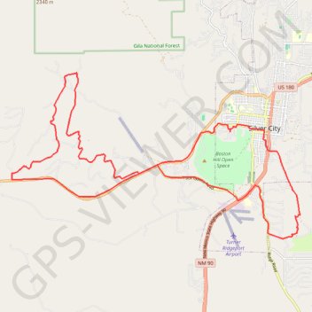
San Vicente RR, Camino de Viento
Morning Ride
- Distance: 20.3 mi
- Elevation gain: 599 m
- Maximum elevation: 1,979 m
- Elevation loss: 596 m
- Minimum elevation: 1,743 m
- Moving time: 1 h 41 m
- Moving speed: 12.0 mph
- Maximum speed: 33.7 mph
- Total time: 1 h 45 m
- Global speed: 11.5 mph
Interactive trail map
Thank you for supporting this site ❤️
Make a donation
Make a donation
Gear up for your next adventure:
As an Amazon Associate, this site earns from qualifying purchases at no extra cost to you.
Trail profile
- Distance: 20.3 mi
- Elevation gain: 599 m
- Maximum elevation: 1,979 m
- Elevation loss: 596 m
- Minimum elevation: 1,743 m
- Moving time: 1 h 41 m
- Moving speed: 12.0 mph
- Maximum speed: 33.7 mph
- Total time: 1 h 45 m
- Global speed: 11.5 mph
Thank you for supporting this site ❤️
Make a donation
Make a donation
Gear up for your next adventure:
As an Amazon Associate, this site earns from qualifying purchases at no extra cost to you.
About this trail
Name: San Vicente RR, Camino de Viento trail, distance, elevation, map, profile, GPS track
Coordinates: 32.73915 -108.36299 32.78686 -108.26406
Thank you for supporting this site ❤️
Make a donation
Make a donation
Gear up for your next adventure:
As an Amazon Associate, this site earns from qualifying purchases at no extra cost to you.
Other hiking, mountain biking, running and outdoor activity trails
Click on a trail to view its statistics, map and profile.