Make a donation
Gear up for your next adventure:
As an Amazon Associate, this site earns from qualifying purchases at no extra cost to you.
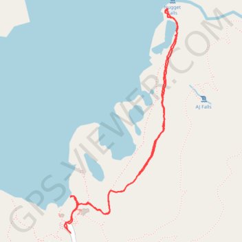
Nugget Falls Trail along Mendenhall Lake in Tongass National Forest
The Nugget Falls Trail offers an exhilarating yet easy hike through the lush rainforests of Tongass National Forest, leading you right to the stunning Nugget Falls. Along the route, you'll be greeted by breathtaking views of Mendenhall Glacier and the unique, milky-blue waters of Mendenhall Lake, a delightful reminder of the area’s glacial origins. As you approach the falls, the invigorating sound of rushing water fills the air, and you can even get up close for a refreshing spray—truly a magical experience that’s perfect for nature lovers of all ages. #Hiking #Lake #Nature #Forest #River #Waterfall #Glacier
- Distance: 2.2 mi
- Elevation gain: 47 m
- Maximum elevation: 28 m
- Elevation loss: 47 m
- Minimum elevation: 15 m
- Moving time: 44 m 28 s
- Moving speed: 2.9 mph
- Maximum speed: 6.9 mph
- Total time: 1 h 5 m
- Global speed: 2.0 mph
Interactive trail map
Make a donation
Gear up for your next adventure:
As an Amazon Associate, this site earns from qualifying purchases at no extra cost to you.
Trail profile
- Distance: 2.2 mi
- Elevation gain: 47 m
- Maximum elevation: 28 m
- Elevation loss: 47 m
- Minimum elevation: 15 m
- Moving time: 44 m 28 s
- Moving speed: 2.9 mph
- Maximum speed: 6.9 mph
- Total time: 1 h 5 m
- Global speed: 2.0 mph
Make a donation
Gear up for your next adventure:
As an Amazon Associate, this site earns from qualifying purchases at no extra cost to you.
About this trail
Name: Nugget Falls Trail along Mendenhall Lake in Tongass National Forest trail, distance, elevation, map, profile, GPS track
Start: Glacier Spur Road, Mendenhall Valley, Juneau, Alaska, United States (58.41636 -134.54706)
End: Glacier Spur Road, Mendenhall Valley, Juneau, Alaska, United States (58.41625 -134.54688)
Coordinates: 58.41620 -134.54734 58.42664 -134.53726
Make a donation
Gear up for your next adventure:
As an Amazon Associate, this site earns from qualifying purchases at no extra cost to you.