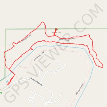
Outcroppings Loop Trail in Tishomingo State Park
The Outcroppings Loop Trail offers a delightful hiking experience, showcasing diverse natural beauty. Along the route, you'll encounter impressive rock formations, lush forests, and a charming waterfall that enhances the scenic appeal of the area. The moderate trail is well-maintained, making it accessible for various skill levels, and provides an immersive encounter with the park's rich flora and fauna. #Hiking #Loop #Forest #Nature #Waterfall
- Distance: 2.1 mi
- Elevation gain: 54 m
- Maximum elevation: 172 m
- Elevation loss: 54 m
- Minimum elevation: 145 m
- Moving time: 57 m 5 s
- Moving speed: 2.2 mph
- Maximum speed: 8.1 mph
- Total time: 1 h 5 m
- Global speed: 1.9 mph
Interactive trail map
Trail profile
- Distance: 2.1 mi
- Elevation gain: 54 m
- Maximum elevation: 172 m
- Elevation loss: 54 m
- Minimum elevation: 145 m
- Moving time: 57 m 5 s
- Moving speed: 2.2 mph
- Maximum speed: 8.1 mph
- Total time: 1 h 5 m
- Global speed: 1.9 mph
About this trail
Name: Outcroppings Loop Trail in Tishomingo State Park trail, distance, elevation, map, profile, GPS track
Coordinates: 34.60392 -88.18027 34.60927 -88.17007