Thank you for supporting this site ❤️
Make a donation
Make a donation
Gear up for your next adventure:
As an Amazon Associate, this site earns from qualifying purchases at no extra cost to you.
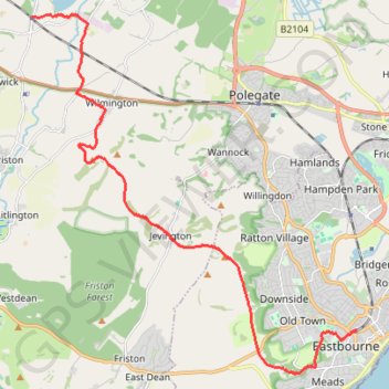
Walk Berwick to Eastbourn
- Distance: 11.2 mi
- Elevation gain: 366 m
- Maximum elevation: 198 m
- Elevation loss: 385 m
- Minimum elevation: 5 m
- Moving time: 3 h 37 m
- Moving speed: 3.1 mph
- Maximum speed: 5.6 mph
- Total time: 4 h 28 m
- Global speed: 2.5 mph
Interactive trail map
Thank you for supporting this site ❤️
Make a donation
Make a donation
Gear up for your next adventure:
As an Amazon Associate, this site earns from qualifying purchases at no extra cost to you.
Trail profile
- Distance: 11.2 mi
- Elevation gain: 366 m
- Maximum elevation: 198 m
- Elevation loss: 385 m
- Minimum elevation: 5 m
- Moving time: 3 h 37 m
- Moving speed: 3.1 mph
- Maximum speed: 5.6 mph
- Total time: 4 h 28 m
- Global speed: 2.5 mph
Thank you for supporting this site ❤️
Make a donation
Make a donation
Gear up for your next adventure:
As an Amazon Associate, this site earns from qualifying purchases at no extra cost to you.
About this trail
Name: Walk Berwick to Eastbourn trail, distance, elevation, map, profile, GPS track
Start: Station Road, Berwick, Wealden, East Sussex, England, BN26 6TA, United Kingdom (50.84061 0.16606)
Coordinates: 50.75995 0.16606 50.84117 0.28214
Topography: Wealden topographic map, elevation, terrain
Thank you for supporting this site ❤️
Make a donation
Make a donation
Gear up for your next adventure:
As an Amazon Associate, this site earns from qualifying purchases at no extra cost to you.