Macbride Waterfall and Coralville Lake Loop in Macbride Nature and Recreation Area
The Macbride Waterfall and Coralville Lake Loop offers a scenic and varied hike that weaves through forested paths and along the shores of Coralville Lake. With views of the lake nearly always in sight, the trail offers both quiet wooded sections and open stretches near the water, making it ideal for spotting local wildlife and seasonal flora. Highlighted by a charming spillway waterfall, the route combines moderate terrain with rewarding natural features that attract hikers seeking a refreshing outdoor experience close to Iowa City. #Hiking #Loop #Lake #Forest #Waterfall #Nature
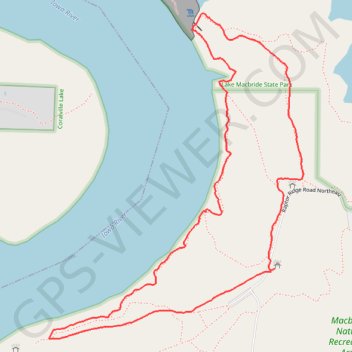
- Distance: 2.0 mi
- Elevation gain: 66 m
- Maximum elevation: 250 m
- Elevation loss: 67 m
- Minimum elevation: 215 m
- Moving time: 42 m 54 s
- Moving speed: 2.9 mph
- Maximum speed: 4.6 mph
- Total time: 45 m 33 s
- Global speed: 2.7 mph
Interactive trail map
Trail profile
- Distance: 2.0 mi
- Elevation gain: 66 m
- Maximum elevation: 250 m
- Elevation loss: 67 m
- Minimum elevation: 215 m
- Moving time: 42 m 54 s
- Moving speed: 2.9 mph
- Maximum speed: 4.6 mph
- Total time: 45 m 33 s
- Global speed: 2.7 mph
About this trail
Name: Macbride Waterfall and Coralville Lake Loop in Macbride Nature and Recreation Area trail, distance, elevation, map, profile, GPS track
Coordinates: 41.78367 -91.57939 41.79239 -91.57025