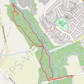
Guelph Walking
Speed River
- Distance: 3.5 mi
- Elevation gain: 27 m
- Maximum elevation: 314 m
- Elevation loss: 26 m
- Minimum elevation: 301 m
- Moving time: 1 h 30 m
- Moving speed: 2.3 mph
- Maximum speed: 9.8 mph
- Total time: 1 h 37 m
- Global speed: 2.2 mph
Interactive trail map
Trail profile
- Distance: 3.5 mi
- Elevation gain: 27 m
- Maximum elevation: 314 m
- Elevation loss: 26 m
- Minimum elevation: 301 m
- Moving time: 1 h 30 m
- Moving speed: 2.3 mph
- Maximum speed: 9.8 mph
- Total time: 1 h 37 m
- Global speed: 2.2 mph
About this trail
Name: Guelph Walking trail, distance, elevation, map, profile, GPS track
Start: Pioneer Trail, Guelph, Ontario, N1C 1B5, Canada (43.50290 -80.24952)
End: Pioneer Trail, Guelph, Wellington County, Ontario, N1C 1B5, Canada (43.50267 -80.24950)
Coordinates: 43.50217 -80.26440 43.51611 -80.24949
Other hiking, mountain biking, running and outdoor activity trails
Click on a trail to view its statistics, map and profile.
Ontario country roads
Distance: 93.4 mi • Elevation gain: 1,137 m • Maximum elevation: 497 m