Make a donation
Gear up for your next adventure:
As an Amazon Associate, this site earns from qualifying purchases at no extra cost to you.
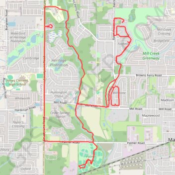
13 Mile Bike, Madison, AL
- Distance: 13.0 mi
- Elevation gain: 128 m
- Maximum elevation: 222 m
- Elevation loss: 128 m
- Minimum elevation: 195 m
- Moving time: 1 h 6 m
- Moving speed: 11.7 mph
- Maximum speed: 21.8 mph
- Total time: 1 h 6 m
- Global speed: 11.7 mph
Interactive trail map
Make a donation
Gear up for your next adventure:
As an Amazon Associate, this site earns from qualifying purchases at no extra cost to you.
Trail profile
- Distance: 13.0 mi
- Elevation gain: 128 m
- Maximum elevation: 222 m
- Elevation loss: 128 m
- Minimum elevation: 195 m
- Moving time: 1 h 6 m
- Moving speed: 11.7 mph
- Maximum speed: 21.8 mph
- Total time: 1 h 6 m
- Global speed: 11.7 mph
Make a donation
Gear up for your next adventure:
As an Amazon Associate, this site earns from qualifying purchases at no extra cost to you.
About this trail
Name: 13 Mile Bike, Madison, AL trail, distance, elevation, map, profile, GPS track
Coordinates: 34.68655 -86.78652 34.72175 -86.76352
Make a donation
Gear up for your next adventure:
As an Amazon Associate, this site earns from qualifying purchases at no extra cost to you.
Other hiking, mountain biking, running and outdoor activity trails
Click on a trail to view its statistics, map and profile.
10 Mile Run, Madison AL
United States > Alabama > Madison County > Madison
Lunch Run
Distance: 10.2 mi • Elevation gain: 100 m • Maximum elevation: 222 m
Bradford Creek Greenway
United States > Alabama > Madison County > Madison
Distance: 4.5 mi • Elevation gain: 37 m • Maximum elevation: 214 m
Bradford Creek Greenway
United States > Alabama > Madison County > Madison
Distance: 5.0 mi • Elevation gain: 37 m • Maximum elevation: 215 m
Bicycle-Madison AL
United States > Alabama > Madison County > Madison
Afternoon Ride
Distance: 10.3 mi • Elevation gain: 103 m • Maximum elevation: 222 m
Make a donation
Gear up for your next adventure:
As an Amazon Associate, this site earns from qualifying purchases at no extra cost to you.