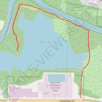
Blue Lake Trail
Pretty flat trail, gravel through most of it, some mud
- Distance: 4.4 mi
- Elevation gain: 41 m
- Maximum elevation: 225 m
- Elevation loss: 41 m
- Minimum elevation: 211 m
- Moving time: 1 h 35 m
- Moving speed: 2.8 mph
- Maximum speed: 3.5 mph
- Total time: 1 h 38 m
- Global speed: 2.7 mph
Interactive trail map
Trail profile
- Distance: 4.4 mi
- Elevation gain: 41 m
- Maximum elevation: 225 m
- Elevation loss: 41 m
- Minimum elevation: 211 m
- Moving time: 1 h 35 m
- Moving speed: 2.8 mph
- Maximum speed: 3.5 mph
- Total time: 1 h 38 m
- Global speed: 2.7 mph
About this trail
Name: Blue Lake Trail trail, distance, elevation, map, profile, GPS track
Start: Shakopee, Scott County, Minnesota, United States (44.79597 -93.42523)
End: Shakopee, Scott County, Minnesota, United States (44.79599 -93.42522)
Coordinates: 44.79597 -93.44110 44.81136 -93.42338