Floratochten 2025 - 17 km 002
- Distance: 10.2 mi
- Elevation gain: 26 m
- Maximum elevation: 11 m
- Elevation loss: 26 m
- Minimum elevation: 3 m
Interactive trail map
Trail profile
- Distance: 10.2 mi
- Elevation gain: 26 m
- Maximum elevation: 11 m
- Elevation loss: 26 m
- Minimum elevation: 3 m
About this trail
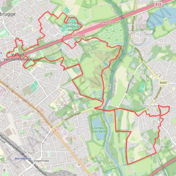
Name: Floratochten 2025 - 17 km 002 trail, distance, elevation, map, profile, GPS track
Coordinates: 51.01846 3.76010 51.04506 3.80528
Other hiking, mountain biking, running and outdoor activity trails
Click on a trail to view its statistics, map and profile.
SDB-Moerzeke-60k
Belgium > East Flanders > Oudenaarde > Zwalm > Sint-Denijs-Boekel
name=SDB-Moerzeke-60k
Distance: 37.8 mi • Elevation gain: 229 m • Maximum elevation: 60 m
Iedereen 1000 KOTK OVL noordlus 131km met Iben en Jana (eindresultaat deze wk 469km gefietst, 23K gelopen en 12K gewandeld)
Belgium > East Flanders > Gent > Heusden
Distance: 80.9 mi • Elevation gain: 579 m • Maximum elevation: 81 m
SDB-Moerzeke 46K
Belgium > East Flanders > Oudenaarde > Zwalm > Sint-Denijs-Boekel
name=SDB-Moerzeke 46K
Distance: 29.0 mi • Elevation gain: 172 m • Maximum elevation: 70 m
Zwalm-Puyenbroeck-68k
Belgium > East Flanders > Oudenaarde > Zwalm > Sint-Denijs-Boekel
name=Zwalm-Puyenbroeck-68k
Distance: 42.4 mi • Elevation gain: 248 m • Maximum elevation: 54 m