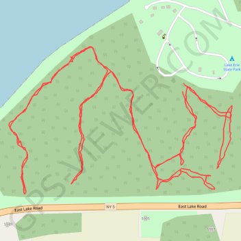
Lake Erie State Park Trail
Hiking
- Distance: 2.5 mi
- Elevation gain: 32 m
- Maximum elevation: 192 m
- Elevation loss: 31 m
- Minimum elevation: 176 m
- Moving time: 59 m 11 s
- Moving speed: 2.6 mph
- Maximum speed: 4.9 mph
- Total time: 1 h 6 m
- Global speed: 2.3 mph
Interactive trail map
Trail profile
- Distance: 2.5 mi
- Elevation gain: 32 m
- Maximum elevation: 192 m
- Elevation loss: 31 m
- Minimum elevation: 176 m
- Moving time: 59 m 11 s
- Moving speed: 2.6 mph
- Maximum speed: 4.9 mph
- Total time: 1 h 6 m
- Global speed: 2.3 mph
About this trail
Name: Lake Erie State Park Trail trail, distance, elevation, map, profile, GPS track
Coordinates: 42.41939 -79.43958 42.42261 -79.43298