Thank you for supporting this site ❤️
Make a donation
Make a donation
Gear up for your next adventure:
As an Amazon Associate, this site earns from qualifying purchases at no extra cost to you.
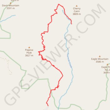
Anderson Trail, Fourmile Falls area
- Distance: 8.9 mi
- Elevation gain: 916 m
- Maximum elevation: 3,528 m
- Elevation loss: 438 m
- Minimum elevation: 2,805 m
- Moving time: 3 h 39 m
- Moving speed: 2.4 mph
- Maximum speed: 3.6 mph
- Total time: 4 h 54 m
- Global speed: 1.8 mph
Interactive trail map
Thank you for supporting this site ❤️
Make a donation
Make a donation
Gear up for your next adventure:
As an Amazon Associate, this site earns from qualifying purchases at no extra cost to you.
Trail profile
- Distance: 8.9 mi
- Elevation gain: 916 m
- Maximum elevation: 3,528 m
- Elevation loss: 438 m
- Minimum elevation: 2,805 m
- Moving time: 3 h 39 m
- Moving speed: 2.4 mph
- Maximum speed: 3.6 mph
- Total time: 4 h 54 m
- Global speed: 1.8 mph
Thank you for supporting this site ❤️
Make a donation
Make a donation
Gear up for your next adventure:
As an Amazon Associate, this site earns from qualifying purchases at no extra cost to you.
About this trail
Name: Anderson Trail, Fourmile Falls area trail, distance, elevation, map, profile, GPS track
Start: Fourmile Stock Drive, Mineral County, Colorado, United States (37.40933 -107.05277)
End: Fourmile Stock Drive, Mineral County, Colorado, United States (37.45701 -107.03560)
Coordinates: 37.40933 -107.06015 37.46873 -107.03560
Thank you for supporting this site ❤️
Make a donation
Make a donation
Gear up for your next adventure:
As an Amazon Associate, this site earns from qualifying purchases at no extra cost to you.