Thank you for supporting this site ❤️
Make a donation
Make a donation
Gear up for your next adventure:
As an Amazon Associate, this site earns from qualifying purchases at no extra cost to you.
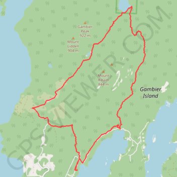
Gambier Island
A walk in the woods
- Distance: 11.3 mi
- Elevation gain: 872 m
- Maximum elevation: 522 m
- Elevation loss: 876 m
- Minimum elevation: 4 m
- Moving time: 4 h 28 m
- Moving speed: 2.5 mph
- Maximum speed: 6.4 mph
- Total time: 4 h 59 m
- Global speed: 2.3 mph
Interactive trail map
Thank you for supporting this site ❤️
Make a donation
Make a donation
Gear up for your next adventure:
As an Amazon Associate, this site earns from qualifying purchases at no extra cost to you.
Trail profile
- Distance: 11.3 mi
- Elevation gain: 872 m
- Maximum elevation: 522 m
- Elevation loss: 876 m
- Minimum elevation: 4 m
- Moving time: 4 h 28 m
- Moving speed: 2.5 mph
- Maximum speed: 6.4 mph
- Total time: 4 h 59 m
- Global speed: 2.3 mph
Thank you for supporting this site ❤️
Make a donation
Make a donation
Gear up for your next adventure:
As an Amazon Associate, this site earns from qualifying purchases at no extra cost to you.
About this trail
Name: Gambier Island trail, distance, elevation, map, profile, GPS track
Coordinates: 49.45934 -123.44241 49.50877 -123.38975
Thank you for supporting this site ❤️
Make a donation
Make a donation
Gear up for your next adventure:
As an Amazon Associate, this site earns from qualifying purchases at no extra cost to you.