Thank you for supporting this site ❤️
Make a donation
Make a donation
Gear up for your next adventure:
As an Amazon Associate, this site earns from qualifying purchases at no extra cost to you.
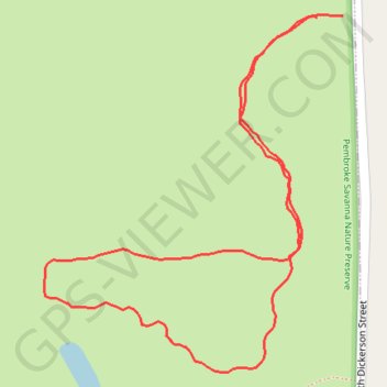
Pembroke Savanna Nature Preserve
- Distance: 0.8 mi
- Elevation gain: 17 m
- Maximum elevation: 217 m
- Elevation loss: 17 m
- Minimum elevation: 206 m
- Moving time: 34 m 47 s
- Moving speed: 1.4 mph
- Maximum speed: 2.4 mph
- Total time: 37 m 9 s
- Global speed: 1.3 mph
Interactive trail map
Thank you for supporting this site ❤️
Make a donation
Make a donation
Gear up for your next adventure:
As an Amazon Associate, this site earns from qualifying purchases at no extra cost to you.
Trail profile
- Distance: 0.8 mi
- Elevation gain: 17 m
- Maximum elevation: 217 m
- Elevation loss: 17 m
- Minimum elevation: 206 m
- Moving time: 34 m 47 s
- Moving speed: 1.4 mph
- Maximum speed: 2.4 mph
- Total time: 37 m 9 s
- Global speed: 1.3 mph
Thank you for supporting this site ❤️
Make a donation
Make a donation
Gear up for your next adventure:
As an Amazon Associate, this site earns from qualifying purchases at no extra cost to you.
About this trail
Name: Pembroke Savanna Nature Preserve trail, distance, elevation, map, profile, GPS track
Coordinates: 41.07272 -87.64323 41.07596 -87.63964
Thank you for supporting this site ❤️
Make a donation
Make a donation
Gear up for your next adventure:
As an Amazon Associate, this site earns from qualifying purchases at no extra cost to you.