Import a GPX file

Route von Oberalm nach/zu Gaisberg (1287 m)

  • Distance: 14.0 mi
  • Elevation gain: 910 m
  • Maximum elevation: 1,286 m
  • Elevation loss: 78 m
  • Minimum elevation: 420 m

Interactive trail map

Trail profile

  • Distance: 14.0 mi
  • Elevation gain: 910 m
  • Maximum elevation: 1,286 m
  • Elevation loss: 78 m
  • Minimum elevation: 420 m

About this trail
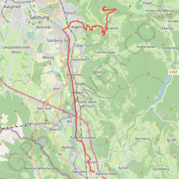
Name: Route von Oberalm nach/zu Gaisberg (1287 m) trail, distance, elevation, map, profile, GPS track

Start: 30, Hammerstraße, Oberalm, Bezirk Hallein, Salzburg, 5411, Austria (47.69334 13.10218)

End: Route 13, Gaisberg, Guggenthal, Salzburg, Bezirk Salzburg-Umgebung, Salzburg, 5321, Austria (47.80512 13.11273)

Coordinates: 47.69325 13.07038 47.80512 13.12361

Gear up for your next adventure:

🛰️Satellite Messengers - Emergency communication devices for areas without mobile signal
🥾Hiking Boot Waterproofing Wax - Maintain the lifespan of your leather trekking boots
🧰Survival Kits - Emergency tools for remote environments
🧴Sport Sunscreen Sticks - High-protection sunblock that won't run into your eyes on the trail
🖼️Topographic Map Art - Decorative 3D-effect posters of famous UK peaks and regions

As an Amazon Associate, this site earns from qualifying purchases at no extra cost to you.