Double Arch Trail in Arches National Park
The Double Arch Trail in Arches National Park offers a brief yet rewarding journey to one of the park's most iconic formations. The path meanders through a desert landscape adorned with red sandstone formations, leading to the impressive Double Arch, where two massive arches converge. The area beneath the arches provides a unique vantage point, allowing visitors to appreciate the intricate rock structures and the expansive sky above. #Hiking #Rock #Desert #Nature #Arch
- Distance: 0.5 mi
- Elevation gain: 37 m
- Maximum elevation: 1,600 m
- Elevation loss: 37 m
- Minimum elevation: 1,563 m
- Moving time: 13 m 37 s
- Moving speed: 2.4 mph
- Maximum speed: 3.6 mph
- Total time: 18 m 52 s
- Global speed: 1.7 mph
Interactive trail map
Trail profile
- Distance: 0.5 mi
- Elevation gain: 37 m
- Maximum elevation: 1,600 m
- Elevation loss: 37 m
- Minimum elevation: 1,563 m
- Moving time: 13 m 37 s
- Moving speed: 2.4 mph
- Maximum speed: 3.6 mph
- Total time: 18 m 52 s
- Global speed: 1.7 mph
About this trail
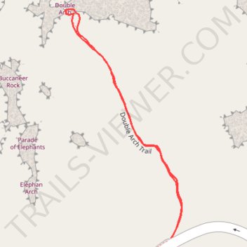
Name: Double Arch Trail in Arches National Park trail, distance, elevation, map, profile, GPS track
Start: Double Arch Trail, Grand County, Utah, United States (38.68832 -109.53838)
End: Double Arch Trail, Grand County, Utah, United States (38.68833 -109.53836)
Coordinates: 38.68832 -109.54028 38.69153 -109.53819
Other hiking, mountain biking, running and outdoor activity trails
Click on a trail to view its statistics, map and profile.