Thank you for supporting this site ❤️
Make a donation
Make a donation
Gear up for your next adventure:
As an Amazon Associate, this site earns from qualifying purchases at no extra cost to you.
Thomas Farm Preserve Loop
- Distance: 3.5 mi
- Elevation gain: 54 m
- Maximum elevation: 219 m
- Elevation loss: 54 m
- Minimum elevation: 190 m
- Moving time: 36 m 37 s
- Moving speed: 5.8 mph
- Maximum speed: 10.4 mph
- Total time: 36 m 37 s
- Global speed: 5.8 mph
Interactive trail map
Thank you for supporting this site ❤️
Make a donation
Make a donation
Gear up for your next adventure:
As an Amazon Associate, this site earns from qualifying purchases at no extra cost to you.
Trail profile
- Distance: 3.5 mi
- Elevation gain: 54 m
- Maximum elevation: 219 m
- Elevation loss: 54 m
- Minimum elevation: 190 m
- Moving time: 36 m 37 s
- Moving speed: 5.8 mph
- Maximum speed: 10.4 mph
- Total time: 36 m 37 s
- Global speed: 5.8 mph
Thank you for supporting this site ❤️
Make a donation
Make a donation
Gear up for your next adventure:
As an Amazon Associate, this site earns from qualifying purchases at no extra cost to you.
About this trail
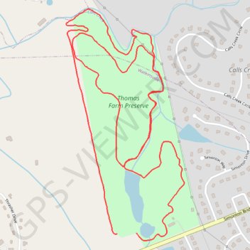
Name: Thomas Farm Preserve Loop trail, distance, elevation, map, profile, GPS track
Coordinates: 33.86741 -83.40515 33.87719 -83.39913
Thank you for supporting this site ❤️
Make a donation
Make a donation
Gear up for your next adventure:
As an Amazon Associate, this site earns from qualifying purchases at no extra cost to you.