Make a donation
Gear up for your next adventure:
As an Amazon Associate, this site earns from qualifying purchases at no extra cost to you.
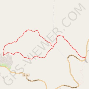
Castle Trail and Medicine Root Trail Loop in Badlands National Park
This loop hike in Badlands National Park offers a good opportunity to explore the park’s unique landscape. The trail takes you through a striking mix of badland formations, mesas, and open prairies, expansive views along the way. Though the trail is exposed with little shade, the gentle terrain and varied scenery, including the impressive Badlands Wall, make for an unforgettable hiking experience. #Hiking #Loop #Nature
- Distance: 6.7 mi
- Elevation gain: 59 m
- Maximum elevation: 810 m
- Elevation loss: 58 m
- Minimum elevation: 788 m
- Moving time: 2 h 41 m
- Moving speed: 2.5 mph
- Maximum speed: 5.3 mph
- Total time: 2 h 52 m
- Global speed: 2.3 mph
Interactive trail map
Make a donation
Gear up for your next adventure:
As an Amazon Associate, this site earns from qualifying purchases at no extra cost to you.
Trail profile
- Distance: 6.7 mi
- Elevation gain: 59 m
- Maximum elevation: 810 m
- Elevation loss: 58 m
- Minimum elevation: 788 m
- Moving time: 2 h 41 m
- Moving speed: 2.5 mph
- Maximum speed: 5.3 mph
- Total time: 2 h 52 m
- Global speed: 2.3 mph
Make a donation
Gear up for your next adventure:
As an Amazon Associate, this site earns from qualifying purchases at no extra cost to you.
About this trail
Name: Castle Trail and Medicine Root Trail Loop in Badlands National Park trail, distance, elevation, map, profile, GPS track
Start: Castle Trail, Jackson County, South Dakota, 57750, United States (43.76127 -101.92855)
Coordinates: 43.76061 -101.97302 43.77234 -101.92772
Make a donation
Gear up for your next adventure:
As an Amazon Associate, this site earns from qualifying purchases at no extra cost to you.
Other hiking, mountain biking, running and outdoor activity trails
Click on a trail to view its statistics, map and profile.