Thank you for supporting this site ❤️
Make a donation
Make a donation
Gear up for your next adventure:
As an Amazon Associate, this site earns from qualifying purchases at no extra cost to you.
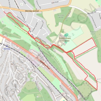
Riddlesdown Walk
- Distance: 3.7 mi
- Elevation gain: 64 m
- Maximum elevation: 164 m
- Elevation loss: 66 m
- Minimum elevation: 132 m
- Moving time: 1 h 10 m
- Moving speed: 3.1 mph
- Maximum speed: 5.8 mph
- Total time: 1 h 37 m
- Global speed: 2.3 mph
Interactive trail map
Thank you for supporting this site ❤️
Make a donation
Make a donation
Gear up for your next adventure:
As an Amazon Associate, this site earns from qualifying purchases at no extra cost to you.
Trail profile
- Distance: 3.7 mi
- Elevation gain: 64 m
- Maximum elevation: 164 m
- Elevation loss: 66 m
- Minimum elevation: 132 m
- Moving time: 1 h 10 m
- Moving speed: 3.1 mph
- Maximum speed: 5.8 mph
- Total time: 1 h 37 m
- Global speed: 2.3 mph
Thank you for supporting this site ❤️
Make a donation
Make a donation
Gear up for your next adventure:
As an Amazon Associate, this site earns from qualifying purchases at no extra cost to you.
About this trail
Name: Riddlesdown Walk trail, distance, elevation, map, profile, GPS track
Coordinates: 51.31817 -0.10156 51.33007 -0.07885
Topography: London topographic map, elevation, terrain
Thank you for supporting this site ❤️
Make a donation
Make a donation
Gear up for your next adventure:
As an Amazon Associate, this site earns from qualifying purchases at no extra cost to you.