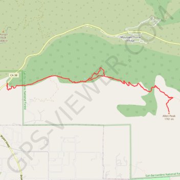
Yucaipa Ridge to Allen Peak
San Bernardino National Forest
- Distance: 9.5 mi
- Elevation gain: 1,007 m
- Maximum elevation: 1,760 m
- Elevation loss: 1,006 m
- Minimum elevation: 893 m
- Moving time: 4 h 52 m
- Moving speed: 2.0 mph
- Maximum speed: 4.8 mph
- Total time: 6 h 40 m
- Global speed: 1.4 mph
Interactive trail map
Trail profile
- Distance: 9.5 mi
- Elevation gain: 1,007 m
- Maximum elevation: 1,760 m
- Elevation loss: 1,006 m
- Minimum elevation: 893 m
- Moving time: 4 h 52 m
- Moving speed: 2.0 mph
- Maximum speed: 4.8 mph
- Total time: 6 h 40 m
- Global speed: 1.4 mph
About this trail
Name: Yucaipa Ridge to Allen Peak trail, distance, elevation, map, profile, GPS track
Start: Mill Creek Road, San Bernardino County, California, United States (34.08854 -117.03931)
End: Mill Creek Road, San Bernardino County, California, United States (34.08865 -117.03921)
Coordinates: 34.08072 -117.03942 34.09276 -116.98526