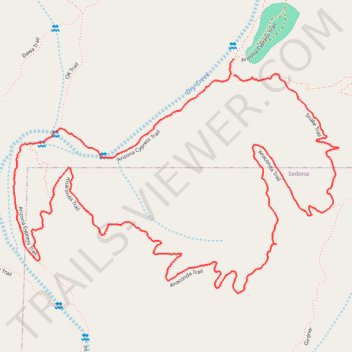
Arizona Cypress Trail, Anaconda Trail and Snake Trail Loop
- Distance: 3.1 mi
- Elevation gain: 99 m
- Maximum elevation: 1,430 m
- Elevation loss: 99 m
- Minimum elevation: 1,339 m
- Moving time: 49 m 43 s
- Moving speed: 3.7 mph
- Maximum speed: 13.4 mph
- Total time: 50 m 53 s
- Global speed: 3.6 mph
Interactive trail map
Trail profile
- Distance: 3.1 mi
- Elevation gain: 99 m
- Maximum elevation: 1,430 m
- Elevation loss: 99 m
- Minimum elevation: 1,339 m
- Moving time: 49 m 43 s
- Moving speed: 3.7 mph
- Maximum speed: 13.4 mph
- Total time: 50 m 53 s
- Global speed: 3.6 mph
About this trail
Name: Arizona Cypress Trail, Anaconda Trail and Snake Trail Loop trail, distance, elevation, map, profile, GPS track
Start: Arizona Cypress Trail, Yavapai County, Arizona, United States (34.89346 -111.83200)
End: Snake Trail, Sedona, Yavapai County, Arizona, 86336, United States (34.89297 -111.83199)
Coordinates: 34.88643 -111.84005 34.89346 -111.82815