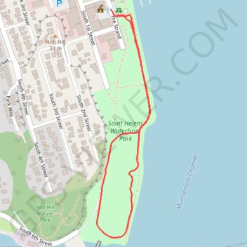
Saint Helens Waterfront Park
- Distance: 1.0 mi
- Elevation gain: 19 m
- Maximum elevation: 14 m
- Elevation loss: 17 m
- Minimum elevation: 4 m
- Moving time: 31 m 7 s
- Moving speed: 2.0 mph
- Maximum speed: 3.0 mph
- Total time: 43 m 28 s
- Global speed: 1.4 mph
Interactive trail map
Trail profile
- Distance: 1.0 mi
- Elevation gain: 19 m
- Maximum elevation: 14 m
- Elevation loss: 17 m
- Minimum elevation: 4 m
- Moving time: 31 m 7 s
- Moving speed: 2.0 mph
- Maximum speed: 3.0 mph
- Total time: 43 m 28 s
- Global speed: 1.4 mph
About this trail
Name: Saint Helens Waterfront Park trail, distance, elevation, map, profile, GPS track
Coordinates: 45.85644 -122.79733 45.86280 -122.79520
Other hiking, mountain biking, running and outdoor activity trails
Click on a trail to view its statistics, map and profile.
Ben Howard (24622956)
United States > Oregon > Multnomah County > Portland
Ben Howard (24622956)
Distance: 225.8 mi • Elevation gain: 11,851 m • Maximum elevation: 1,007 m