Thank you for supporting this site ❤️
Make a donation
Make a donation
Gear up for your next adventure:
As an Amazon Associate, this site earns from qualifying purchases at no extra cost to you.
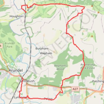
Walk Amberley to Arundel via Amberley Mount, Wepham Down, Black Ditch, Lynminster
Amberley, Arundel, Amberley Mount, Wepham Down, Black Ditch, Lynminster
- Distance: 14.4 mi
- Elevation gain: 314 m
- Maximum elevation: 194 m
- Elevation loss: 320 m
- Minimum elevation: -2 m
- Moving time: 5 h 58 m
- Moving speed: 2.4 mph
- Maximum speed: 4.9 mph
- Total time: 7 h 18 m
- Global speed: 2.0 mph
Interactive trail map
Thank you for supporting this site ❤️
Make a donation
Make a donation
Gear up for your next adventure:
As an Amazon Associate, this site earns from qualifying purchases at no extra cost to you.
Trail profile
- Distance: 14.4 mi
- Elevation gain: 314 m
- Maximum elevation: 194 m
- Elevation loss: 320 m
- Minimum elevation: -2 m
- Moving time: 5 h 58 m
- Moving speed: 2.4 mph
- Maximum speed: 4.9 mph
- Total time: 7 h 18 m
- Global speed: 2.0 mph
Thank you for supporting this site ❤️
Make a donation
Make a donation
Gear up for your next adventure:
As an Amazon Associate, this site earns from qualifying purchases at no extra cost to you.
About this trail
Name: Walk Amberley to Arundel via Amberley Mount, Wepham Down, Black Ditch, Lynminster trail, distance, elevation, map, profile, GPS track
Coordinates: 50.83189 -0.54941 50.90335 -0.47217
Topography: West Sussex topographic map, elevation, terrain
Thank you for supporting this site ❤️
Make a donation
Make a donation
Gear up for your next adventure:
As an Amazon Associate, this site earns from qualifying purchases at no extra cost to you.