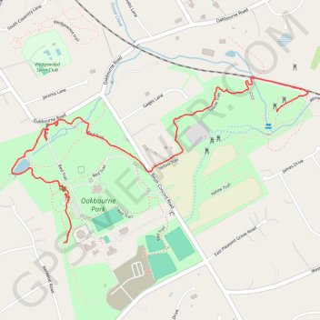
Oakbourne Park
- Distance: 1.6 mi
- Elevation gain: 20 m
- Maximum elevation: 141 m
- Elevation loss: 55 m
- Minimum elevation: 98 m
- Moving time: 38 m 2 s
- Moving speed: 2.6 mph
- Maximum speed: 6.4 mph
- Total time: 41 m 31 s
- Global speed: 2.4 mph
Interactive trail map
Trail profile
- Distance: 1.6 mi
- Elevation gain: 20 m
- Maximum elevation: 141 m
- Elevation loss: 55 m
- Minimum elevation: 98 m
- Moving time: 38 m 2 s
- Moving speed: 2.6 mph
- Maximum speed: 6.4 mph
- Total time: 41 m 31 s
- Global speed: 2.4 mph
About this trail
Name: Oakbourne Park trail, distance, elevation, map, profile, GPS track
Coordinates: 39.93511 -75.57784 39.94097 -75.56421