Import a GPX file

Saluda Riverwalk

Hike along Saluda River in Columbia. #Hiking #Nature #River #Forest

  • Distance: 3.4 mi
  • Elevation gain: 44 m
  • Maximum elevation: 51 m
  • Elevation loss: 44 m
  • Minimum elevation: 41 m
  • Moving time: 39 m 27 s
  • Moving speed: 5.2 mph
  • Maximum speed: 9.5 mph
  • Total time: 46 m 47 s
  • Global speed: 4.4 mph

Interactive trail map

Trail profile

  • Distance: 3.4 mi
  • Elevation gain: 44 m
  • Maximum elevation: 51 m
  • Elevation loss: 44 m
  • Minimum elevation: 41 m
  • Moving time: 39 m 27 s
  • Moving speed: 5.2 mph
  • Maximum speed: 9.5 mph
  • Total time: 46 m 47 s
  • Global speed: 4.4 mph

About this trail

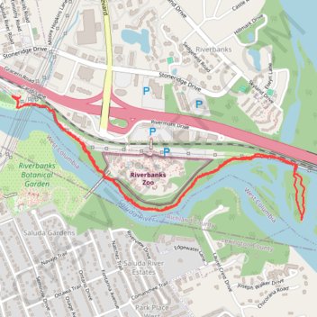
Name: Saluda Riverwalk trail, distance, elevation, map, profile, GPS track

Start: Saluda Riverwalk, Columbia, Richland County, South Carolina, 29169, United States (34.01330 -81.08172)

End: Saluda Riverwalk, Columbia, Richland County, South Carolina, 29169, United States (34.01328 -81.08179)

Coordinates: 34.00640 -81.08233 34.01334 -81.06254

Gear up for your next adventure:

🧦Hiking Socks - Breathable socks designed to prevent blisters on long walks
🧊Insulated Flasks - Keeps drinks hot or cold during hikes
🧤Waterproof Overmitts - Extreme weather protection for hikers and mountaineers
🐕Dog Hiking Gear - Equipment for hiking safely with dogs
📱Phone Mounts for Hiking - Secure mounts to carry your phone on trails

As an Amazon Associate, this site earns from qualifying purchases at no extra cost to you.