Import a GPX file

Overlooking Loch Kathrine

#GB #Scotland

  • Distance: 7.1 mi
  • Elevation gain: 274 m
  • Maximum elevation: 293 m
  • Elevation loss: 270 m
  • Minimum elevation: 117 m
  • Moving time: 3 h 6 m
  • Moving speed: 2.3 mph
  • Maximum speed: 5.0 mph
  • Total time: 4 h 26 m
  • Global speed: 1.6 mph

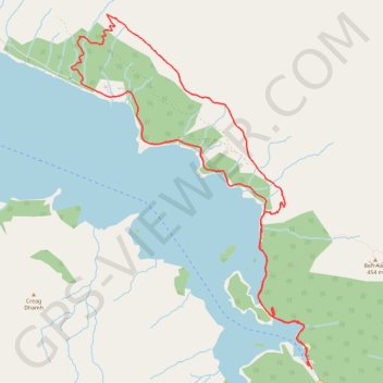
Interactive trail map

Trail profile

  • Distance: 7.1 mi
  • Elevation gain: 274 m
  • Maximum elevation: 293 m
  • Elevation loss: 270 m
  • Minimum elevation: 117 m
  • Moving time: 3 h 6 m
  • Moving speed: 2.3 mph
  • Maximum speed: 5.0 mph
  • Total time: 4 h 26 m
  • Global speed: 1.6 mph

About this trail

Name: Overlooking Loch Kathrine trail, distance, elevation, map, profile, GPS track

Start: A821, Stirling, Scotland, FK17 8HZ, United Kingdom (56.23336 -4.42847)

End: A821, Stirling, Scotland, FK17 8HZ, United Kingdom (56.23365 -4.42907)

Coordinates: 56.23336 -4.46541 56.26359 -4.42847

Topography: Stirling topographic map, elevation, terrain

Other hiking, mountain biking, running and outdoor activity trails

Click on a trail to view its statistics, map and profile.

Munro hillwalk Meall Dearg Sgorr nam Fiannaidh Aonach Eagach

United Kingdom > Scotland > Highland

#Munro #hillwalk #Meall #Dearg #Aonach #Eagach

Distance: 107.8 mi • Elevation gain: 2,915 m • Maximum elevation: 962 m

Gear up for your next adventure:

👖Packable Overtrousers - Quick-deploy rain protection for legs in sudden storms
🥄Titanium Camping Sporks - The ultimate lightweight utensil for trail meals
📻Hand-Crank Emergency Radios - Stay updated on weather warnings in remote areas
👕Merino Base Layers - Natural temperature regulation for cold weather hiking and camping
🧴Sport Sunscreen Sticks - High-protection sunblock that won't run into your eyes on the trail

As an Amazon Associate, this site earns from qualifying purchases at no extra cost to you.