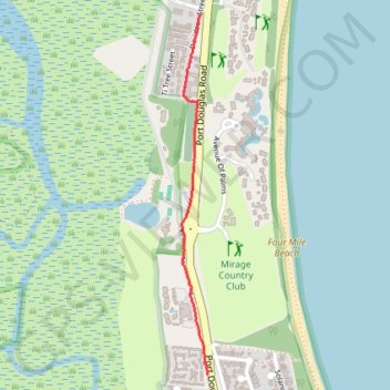
Port Douglas to Ramada resort walk
Port Douglas walk
- Distance: 1.2 mi
- Elevation gain: 5 m
- Maximum elevation: 10 m
- Elevation loss: 3 m
- Minimum elevation: 6 m
- Moving time: 24 m 7 s
- Moving speed: 3.0 mph
- Maximum speed: 5.3 mph
- Total time: 24 m 7 s
- Global speed: 3.0 mph
Interactive trail map
Trail profile
- Distance: 1.2 mi
- Elevation gain: 5 m
- Maximum elevation: 10 m
- Elevation loss: 3 m
- Minimum elevation: 6 m
- Moving time: 24 m 7 s
- Moving speed: 3.0 mph
- Maximum speed: 5.3 mph
- Total time: 24 m 7 s
- Global speed: 3.0 mph
About this trail
Name: Port Douglas to Ramada resort walk trail, distance, elevation, map, profile, GPS track
Start: 115, Davidson Street, Port Douglas, Douglas Shire, Queensland, 4877, Australia (-16.49669 145.46337)
End: Port Douglas Road, Port Douglas, Douglas Shire, Queensland, 4877, Australia (-16.51282 145.46373)
Coordinates: -16.51282 145.46252 -16.49669 145.46373