Goldenfields Reserve
Walkin' while the kids were playin'
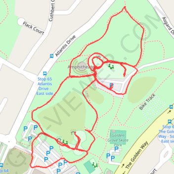
- Distance: 1.6 mi
- Elevation gain: 51 m
- Maximum elevation: 210 m
- Elevation loss: 51 m
- Minimum elevation: 178 m
- Moving time: 34 m 11 s
- Moving speed: 2.7 mph
- Maximum speed: 3.7 mph
- Total time: 43 m 28 s
- Global speed: 2.2 mph
Interactive trail map
Trail profile
- Distance: 1.6 mi
- Elevation gain: 51 m
- Maximum elevation: 210 m
- Elevation loss: 51 m
- Minimum elevation: 178 m
- Moving time: 34 m 11 s
- Moving speed: 2.7 mph
- Maximum speed: 3.7 mph
- Total time: 43 m 28 s
- Global speed: 2.2 mph
About this trail
Name: Goldenfields Reserve trail, distance, elevation, map, profile, GPS track
Coordinates: -34.78785 138.69919 -34.78434 138.70221
Other hiking, mountain biking, running and outdoor activity trails
Click on a trail to view its statistics, map and profile.
Cobbler Creek Recreation Park and Martindale Reserve
Australia > South Australia > Adelaide
Distance: 18.7 mi • Elevation gain: 671 m • Maximum elevation: 219 m
Cobbler Creek Recreation Park
Australia > South Australia > Adelaide
Distance: 12.5 mi • Elevation gain: 358 m • Maximum elevation: 219 m
Dry Creek to the Triangle
Australia > South Australia > Adelaide
Distance: 13.2 mi • Elevation gain: 174 m • Maximum elevation: 204 m
Dry Creek Trail
Australia > South Australia > Adelaide
Distance: 14.0 mi • Elevation gain: 263 m • Maximum elevation: 204 m