
Manistee River Loop
Starting near Hodenpyl Dam Pond, the Manistee River Loop heads onto the North Country National Scenic Trail, following the wooded western side of the valley through hardwood forest, quiet ridges, and backcountry stretches above the Big Manistee River toward the Red Bridge area.
From Red Bridge, the route returns north on the Manistee River Trail, tracing the river’s eastern side through rolling forest, wetlands, creek crossings, riverbank viewpoints, rustic campsites, and the Stagle Creek Overlook.
Near the northern end of the loop, the trail reaches the celebrated Little Mac suspension bridge, where hikers cross the Manistee River back toward Hodenpyl Dam Pond and complete one of the classic forest-and-river circuits of the Manistee National Forest.
#Hiking #Loop #River #Nature #Forest #Lake #Dam #Overlook
- Distance: 20.1 mi
- Elevation gain: 697 m
- Maximum elevation: 345 m
- Elevation loss: 698 m
- Minimum elevation: 211 m
- Moving time: 7 h 42 m
- Moving speed: 2.6 mph
- Maximum speed: 3.8 mph
- Total time: 8 h 31 m
- Global speed: 2.4 mph
Interactive trail map
Trail profile
- Distance: 20.1 mi
- Elevation gain: 697 m
- Maximum elevation: 345 m
- Elevation loss: 698 m
- Minimum elevation: 211 m
- Moving time: 7 h 42 m
- Moving speed: 2.6 mph
- Maximum speed: 3.8 mph
- Total time: 8 h 31 m
- Global speed: 2.4 mph
About this trail
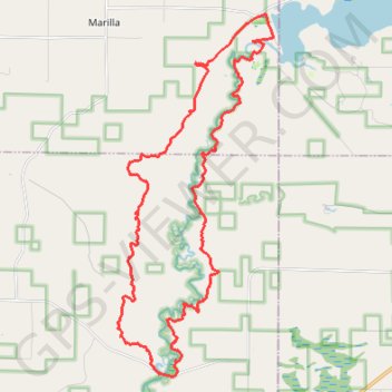
Name: Manistee River Loop trail, distance, elevation, map, profile, GPS track
Start: Blueberry Lane, Marilla Township, Manistee County, Michigan, United States (44.37268 -85.82518)
Coordinates: 44.28327 -85.87623 44.37271 -85.82234