Thank you for supporting this site ❤️
Make a donation
Make a donation
Gear up for your next adventure:
As an Amazon Associate, this site earns from qualifying purchases at no extra cost to you.
Lerderderg Gorge
Lerderderg State Park. #Hiking #Loop #Lerderderg
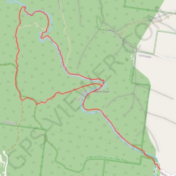
- Distance: 5.2 mi
- Elevation gain: 375 m
- Maximum elevation: 440 m
- Elevation loss: 377 m
- Minimum elevation: 133 m
Interactive trail map
Thank you for supporting this site ❤️
Make a donation
Make a donation
Gear up for your next adventure:
As an Amazon Associate, this site earns from qualifying purchases at no extra cost to you.
Trail profile
- Distance: 5.2 mi
- Elevation gain: 375 m
- Maximum elevation: 440 m
- Elevation loss: 377 m
- Minimum elevation: 133 m
Thank you for supporting this site ❤️
Make a donation
Make a donation
Gear up for your next adventure:
As an Amazon Associate, this site earns from qualifying purchases at no extra cost to you.
About this trail
Name: Lerderderg Gorge trail, distance, elevation, map, profile, GPS track
Coordinates: -37.61546 144.40390 -37.59629 144.42546
Thank you for supporting this site ❤️
Make a donation
Make a donation
Gear up for your next adventure:
As an Amazon Associate, this site earns from qualifying purchases at no extra cost to you.
Other hiking, mountain biking, running and outdoor activity trails
Click on a trail to view its statistics, map and profile.
Lerderderg Gorge via Long Point Track
Distance: 5.0 mi • Elevation gain: 372 m • Maximum elevation: 440 m