Thank you for supporting this site ❤️
Make a donation
Make a donation
Gear up for your next adventure:
As an Amazon Associate, this site earns from qualifying purchases at no extra cost to you.
Bairnsdale - Lakes Entrance
#Bike
- Distance: 23.9 mi
- Elevation gain: 318 m
- Maximum elevation: 91 m
- Elevation loss: 323 m
- Minimum elevation: 1 m
Interactive trail map
Thank you for supporting this site ❤️
Make a donation
Make a donation
Gear up for your next adventure:
As an Amazon Associate, this site earns from qualifying purchases at no extra cost to you.
Trail profile
- Distance: 23.9 mi
- Elevation gain: 318 m
- Maximum elevation: 91 m
- Elevation loss: 323 m
- Minimum elevation: 1 m
Thank you for supporting this site ❤️
Make a donation
Make a donation
Gear up for your next adventure:
As an Amazon Associate, this site earns from qualifying purchases at no extra cost to you.
About this trail
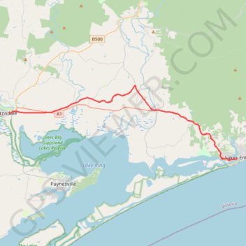
Name: Bairnsdale - Lakes Entrance trail, distance, elevation, map, profile, GPS track
Coordinates: -37.88298 147.63746 -37.79260 147.98641
Thank you for supporting this site ❤️
Make a donation
Make a donation
Gear up for your next adventure:
As an Amazon Associate, this site earns from qualifying purchases at no extra cost to you.
Other hiking, mountain biking, running and outdoor activity trails
Click on a trail to view its statistics, map and profile.
Sale - Bairnsdale
#Bike
Distance: 44.7 mi • Elevation gain: 254 m • Maximum elevation: 55 m