Thank you for supporting this site ❤️
Make a donation
Make a donation
Gear up for your next adventure:
As an Amazon Associate, this site earns from qualifying purchases at no extra cost to you.
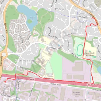
Pathway in Priorslee
- Distance: 1.8 mi
- Elevation gain: 39 m
- Maximum elevation: 163 m
- Elevation loss: 25 m
- Minimum elevation: 126 m
- Moving time: 30 m 29 s
- Moving speed: 3.6 mph
- Maximum speed: 4.8 mph
- Total time: 30 m 29 s
- Global speed: 3.6 mph
Interactive trail map
Thank you for supporting this site ❤️
Make a donation
Make a donation
Gear up for your next adventure:
As an Amazon Associate, this site earns from qualifying purchases at no extra cost to you.
Trail profile
- Distance: 1.8 mi
- Elevation gain: 39 m
- Maximum elevation: 163 m
- Elevation loss: 25 m
- Minimum elevation: 126 m
- Moving time: 30 m 29 s
- Moving speed: 3.6 mph
- Maximum speed: 4.8 mph
- Total time: 30 m 29 s
- Global speed: 3.6 mph
Thank you for supporting this site ❤️
Make a donation
Make a donation
Gear up for your next adventure:
As an Amazon Associate, this site earns from qualifying purchases at no extra cost to you.
About this trail
Name: Pathway in Priorslee trail, distance, elevation, map, profile, GPS track
Coordinates: 52.68044 -2.43464 52.68937 -2.41379
Topography: Telford and Wrekin topographic map, elevation, terrain
Thank you for supporting this site ❤️
Make a donation
Make a donation
Gear up for your next adventure:
As an Amazon Associate, this site earns from qualifying purchases at no extra cost to you.
Other hiking, mountain biking, running and outdoor activity trails
Click on a trail to view its statistics, map and profile.
Around Priorslee
United Kingdom > England > Telford and Wrekin > Priorslee Village
Distance: 3.4 mi • Elevation gain: 58 m • Maximum elevation: 161 m