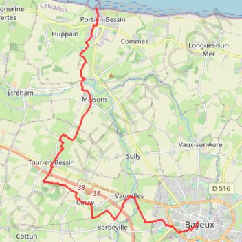
PortEnBessin-Bayeux
- Distance: 10.9 mi
- Elevation gain: 156 m
- Maximum elevation: 67 m
- Elevation loss: 107 m
- Minimum elevation: 0 m
Interactive trail map
Trail profile
- Distance: 10.9 mi
- Elevation gain: 156 m
- Maximum elevation: 67 m
- Elevation loss: 107 m
- Minimum elevation: 0 m
About this trail
Name: PortEnBessin-Bayeux trail, distance, elevation, map, profile, GPS track
Coordinates: 49.27347 -0.78328 49.34928 -0.70289
Other hiking, mountain biking, running and outdoor activity trails
Click on a trail to view its statistics, map and profile.
Arromanches PortenBessin
France > Normandy > Calvados > Arromanches-les-Bains
Distance: 8.6 mi • Elevation gain: 197 m • Maximum elevation: 74 m
Bayeux boucle ouest longue
France > Normandy > Calvados > Bayeux
Distance: 46.3 mi • Elevation gain: 547 m • Maximum elevation: 76 m
PortEnBessin Loop
France > Normandy > Calvados > Port-en-Bessin-Huppain
Distance: 15.3 mi • Elevation gain: 279 m • Maximum elevation: 78 m
Bayeux-Caen Long
France > Normandy > Calvados > Bayeux
Distance: 39.9 mi • Elevation gain: 458 m • Maximum elevation: 77 m
Bayeux Boucle ouest courte
France > Normandy > Calvados > Bayeux
Distance: 35.3 mi • Elevation gain: 440 m • Maximum elevation: 76 m
Bayeux East short loop
France > Normandy > Calvados > Bayeux
Distance: 17.5 mi • Elevation gain: 223 m • Maximum elevation: 74 m