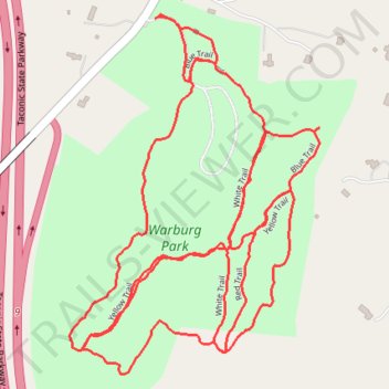
Warburg Park trails
- Distance: 2.8 mi
- Elevation gain: 53 m
- Maximum elevation: 173 m
- Elevation loss: 52 m
- Minimum elevation: 151 m
- Moving time: 50 m 57 s
- Moving speed: 3.3 mph
- Maximum speed: 5.3 mph
- Total time: 52 m 19 s
- Global speed: 3.2 mph
Interactive trail map
Trail profile
- Distance: 2.8 mi
- Elevation gain: 53 m
- Maximum elevation: 173 m
- Elevation loss: 52 m
- Minimum elevation: 151 m
- Moving time: 50 m 57 s
- Moving speed: 3.3 mph
- Maximum speed: 5.3 mph
- Total time: 52 m 19 s
- Global speed: 3.2 mph
About this trail
Name: Warburg Park trails trail, distance, elevation, map, profile, GPS track
Coordinates: 41.19553 -73.80596 41.20192 -73.80006
Other hiking, mountain biking, running and outdoor activity trails
Click on a trail to view its statistics, map and profile.