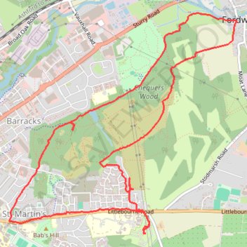
Walk around Canterbury area
- Distance: 5.8 mi
- Elevation gain: 89 m
- Maximum elevation: 54 m
- Elevation loss: 89 m
- Minimum elevation: 2 m
- Moving time: 2 h 23 m
- Moving speed: 2.4 mph
- Maximum speed: 9.5 mph
- Total time: 5 h 29 m
- Global speed: 1.1 mph
Interactive trail map
Trail profile
- Distance: 5.8 mi
- Elevation gain: 89 m
- Maximum elevation: 54 m
- Elevation loss: 89 m
- Minimum elevation: 2 m
- Moving time: 2 h 23 m
- Moving speed: 2.4 mph
- Maximum speed: 9.5 mph
- Total time: 5 h 29 m
- Global speed: 1.1 mph
About this trail
Name: Walk around Canterbury area trail, distance, elevation, map, profile, GPS track
Coordinates: 51.27636 1.09277 51.29589 1.12516
Topography: Canterbury topographic map, elevation, terrain
Other hiking, mountain biking, running and outdoor activity trails
Click on a trail to view its statistics, map and profile.
Coastal MTB loop from Canterbury in Kent Downs National Landscape
United Kingdom > England > Kent > Canterbury
Mountain biking loop from Canterbury via Folkestone, Dover, Deal and Sandwich.
Distance: 56.6 mi • Elevation gain: 834 m • Maximum elevation: 186 m